![]()
The Hiking Website of Fred Triep
|
|
|
|
|||
|
|
(translation of the Dutch page
by Mary Smit- Ryan)
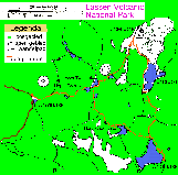 |
Click on the map if you
would like to see a large detailed map 399 KB |
I have made this map, grounded on the 1:48.000 map of Earthwalk Press (see literature)
General description
Lassen Volcanic National Park lies across the Cascades in Northern California. It has been made into a national park because of, among other things, the presence of the volcano, Lassen Peak (3187 metres) which erupted at the beginning of the 20th century. Besides this volcano, you will also find traces of volcanic activity, such as mud pools, fumaroles, etc.
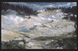 |
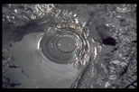
The large photo on the
left is 101 Kb and that on the right 103 Kb Left: Bumpass Hell in the south of the park is an area with mud pools, fumaroles and other traces of volcanic activity Right: Boiling mud pool in Bumpass Hell |
 |
The larger part of the park is covered with
pine woods, where you find numerous lakes. Some parts are bare due to earlier or
more recent volcanic eruptions. The area of the hike lies between Summit Lake (to
the east of Lassen Peak) and Cinder Cone.
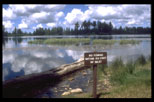
If you want to take a hike of a number of days in a National Park, Monument or
Wilderness Area, you need a backpacking permit on which the places to stay
overnight are marked. You can get this permit free at a ranger�s station, if
you ask for it.
Detailed description
Before starting out on this walking-tour we had a one-day walk from the parking lot at the foot of the mountain (2590m) to the top of Lassen Peak on Sunday, 6 July 1997.
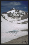 |
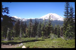
The large photograph on
the left is 86Kb Left: View of Lassen Peak from the foot of the mountain
|
The walking route is marked with a red line on the detailed map. The direction walked is shown with arrow points.
Monday, 7 July 1997
The last few days we camped on the camping ground to the north of Summit Lake (2050 m) On Monday morning we parked our car on the road at the ranger station From there we walked up the path and followed the path to Echo Lake (2170m) and Upper Twin Lake (2010m).
 |
Large photo left is 57 Kb Left: Walking up to Upper Twin Lake, we see behind us the white peek of Lassen rising above the trees
|
After a break at the Upper Twin Lake, we continued our trek along the Lower Twin Lake to Rainbow Lake (1975m).
 |
Large photo left is 86 Kb Left: We are walking around Lower Twin Lake
|
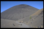
There we took the path to Cinder Cone. After walking for some time we came in the bare landscape of Cinder Cone and saw the heaps of lava stone of Painted Dunes. Walking through the gully of lava grit was very tiring. I walked on to the foot of the Cinder Cone.
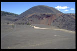 |
Large photo left is 73
Kb, right 61Kb Left and right: View of Cinder Cone and Painted Dunes (right) |
 |
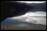
From Cinder Cone we walked via a side path to the place called Panther Spring on Snag Lake, where we pitched our tent under some trees at some distance from the lake (1850m). We had walked about 14 kilometres that day. Because this was not a camping ground we had to hang our food in the trees.
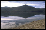 |
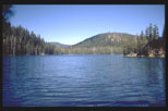
Large photo left is 71
Kb, right 72 Kb Left: Snag Lake Right: The north side of Snag Lake (on the left of the photo) has been dammed up by a volcano eruption |
 |
Tuesday, 8 July 1997
In the morning we walked along the West side of Snag Lake going south. On the south side of the lake we walked for some time through a burnt-out wood. At the furthest point of the lake we took a path going up to Cameron Meadow, a marshy field with a stream running through it at a height of 1950 m..
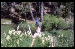 |
Large photo left is 144
Kb Left: The path runs through the marshy field of Cameron Meadow |
The path climbed to 2170 m, from where we
descended to Jupiter Lake (2070 m). We pitched our tent on the official camping
ground at the east side of the lake.
We had walked about 12 km that day. That evening our "neighbours" lent
us their canoe so that we could make a trip by moonlight on Jupiter Lake.
Wednesday, 9 July 1997
We walked along the east side of the lake and
back to the most northerly point. From there we took a path leading up to
Horseshoe Lake, where we took a break. After that we walked around the
right-side of the lake and took the path to Lower Twin Lake. From that lake we
took the same way back which we had taken on the way there on Monday. Altogether,
we walked 18 km that day. At the end of the afternoon we reached the ranger
station at Summit Lake and from there we took the car to the camping ground at
Manzanita Lake.
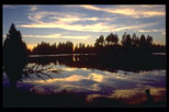
That evening and the following day I took pictures of the lovely Manzanita Lake.
 |
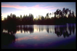 |
The large photos are
68Kb, 65Kb and 91Kb, respectively Left and right: Manzanita Lake at sunset and in the daytime |
 |
Literature
Stephen H. Matteson
Lassen Trails
A brief guide to the trails of Lassen Volcanic National Park
Loomes Museum Association & National Park Service, 1992
Map Material
A suitable map for taking hikes (one-day hikes or hikes for more than one day) in this area is:
| Hiking Map & Guide, schaal 1:48.000 Lassen Volcanic National Park Earthwalk Press, 1993 Eureka, CA 95501 |
 |
You can order this map from Yahoo. |
Interesting links about hiking in Lassen Volcanic National Park
On the following homepages attention is given to Lassen National Park and/or hiking in this area:
This page has been made new on Wednesday, 22 May 2002.
![]()
For additions or reactions, you can e-mail me: